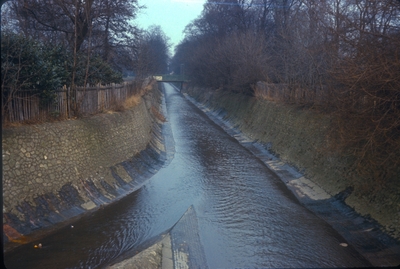
Nicklin, Phyllis (1967) Birmingham Cannon Hill Park. Confluence of the River Rea (Right), Bourne Brook (Left). [Image] (Unpublished)
 Image (JPEG) Available under License  . .Edg00012.jpg 1726Kb |
Abstract
Birmingham Cannon Hill Park. Confluence of the River Rea (Right), Bourne Brook (Left). View North
| Type of Work: | Image | ||||||
|---|---|---|---|---|---|---|---|
| School/Faculty: | Faculties (to 1997) > Faculty of Education | ||||||
| Department: | Department of Extramural Studies | ||||||
| Additional Information: | Scanned by Brumpic from original 35mm slide number 7140 held at the University of Birmingham. | ||||||
| Date: | 11 February 1967 | ||||||
| Location: | See the location now via Google Maps (52.4508,-1.9072) | ||||||
| Projects: | Brumpic Digitisation | ||||||
| Series/Collection Name: | Birmingham's Buildings and Urban Topography | ||||||
| Keywords: | Edgbaston, Birmingham, Cannon Hill Park, River Rea | ||||||
| Subjects: | H Social Sciences > HC Economic History and Conditions H Social Sciences > HN Social history and conditions. Social problems. Social reform D History General and Old World > DA Great Britain | ||||||
| Copyright Status: | Copyright and database rights in this material belong to the University of Birmingham. The photographic image is available to download and redistribute for non-commercial purposes. | ||||||
| Copyright Holders: | University of Birmingham | ||||||
| Remote Supplementary Files: |
| ||||||
| ID Code: | 2745 |
|
Repository Staff Only: item control page


